You
know, directions, place names such as Nahom, plausible locations for
Bountiful, Shazer, and the Valley of Lemuel, and so
forth?
Click Image to Magnify
Somehow
this map must hold the answer, but I need a little help to see how.
Maybe the answer is in the earlier book of Jedidiah Morse, Geography
Made Easy. It can be viewed online.
I've
been looking through it but don't see anything that Joseph Smith
could have used to fabricate his gems in First Nephi. Can you offer
any help? Help is what I need in order to respond to this email from
a skeptic:
You
write like an intelligent person. How is it you are still mired in
LDS quicksand. Your comments on how Joseph Smith knew so much about
the Arabian peninsula is without merit.
There
existed in his time a school book entitled Geography Made
Easy, Jedidiah Morse,1813. Smith lived just 2 miles from
Palmyra,NY. Where there were several bookstores and a library. No
record of his visit though. He also received regularly the Palmyra
Register, and later the Wayne Sentinel. The offices of which served
double duty as a library. He had ample access to this information.
Not
a very big leap of prophecy. More than a small step.
How
do you respond to this fact!
I'm
missing something here, so I'd appreciate your help. Just how does
Jedidiah Morse provide Joseph Smith with the information he needed to
impress so many of us over 150 years later with the apparent "direct
hits" in the Arabian Peninsula?
Our
critic, of course, was behind the times. There were better maps in
Joseph's day, though they probably weren't available to him. Printed
in Europe as high-end productions, some of them predating the Book of
Mormon have an important advantage: they show a name related to
Nahom, written as either Nehem or Nehhm, in the district north of
Sanaa that has long been associated with the Nihm tribe.
Is
that where Joseph got Nahom? And is that where he got the Valley of
Lemuel, the River Laman, Shazer, the eastward turn at Nahom, and the
remarkable place Bountiful?
You
can also view high-resolution images of many maps of Arabia in the
David Rumsey collection at DavidRumsey.com.
Perhaps
the most promising candidate proposed by critics as Joseph's magical
map for crafting First Nephi is the “New Modern Map of Arabia,”
D’Anville, with Improvements by Niebuhr, published by Laurie &
Whittle (London, 1794).
In
1794 they published a guide for travelers in the Middle East called
“The Oriental Navigator,” which included a beautiful map
of Arabia. You can
see it in detail at DavidRumsey.com.
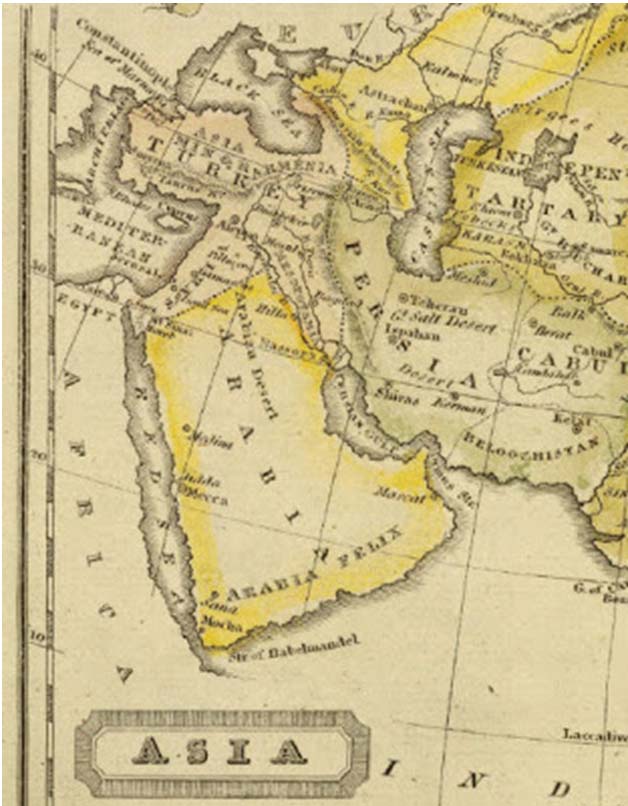
Here's a close-up of the region around the Valley of Lemuel and the
River Laman. Now do you see how Joseph came up with that? Perhaps
not.
Click Image to Magnify
Here's
the section with Nehem. Yes, it's there. Now can you see evidence for
Bountiful on the east coast? If so, please let me know! And if you
can tell that Nahom is where the trail turns east, also help me see
that. At my age, my eyes just aren't as sharp as they used to be.
Take
a look at any of the old Arabian maps and tell me how anyone or any
group collectively can explain First Nephi. And also please tell me
why Joseph neglected so many of the treasures on these maps?
If
he used a map to add a little "local color" as one
professor claims, where is the color? Why pluck one minor element
that nobody has ever heard of and neglect all the interesting sites
that would have provided such color? Mecca, Medina, Arabia Felix,
Jethro's Cave, etc. — why neglect those treasures in favor of
one obscure name?
And
if you knew that your story had some evidence built into it like a
name matching an actual place on a relatively unknown map, why not
later have one of your peers pretend present the map to the world and
announce the excite correspondence?
Why
neglect the evidence that you went to the trouble of building into
the Book of Mormon, leaving it for future generations to discover on
their own nearly 150 years later? Theories of fabrication based on
Joseph's study of a map do little to explain the origins of the Book
of Mormon and raise more serious questions than they answer.
The
problem with these more advanced maps is that they were much less
likely to have been available to Joseph Smith. Jedidiah Morse's map
was within reach of Joseph if he had wanted to study Morse and learn
a little geography.
As
for maps showing Nehem/Nehhm, so far there's no evidence of any being
within 100 miles of Joseph Smith, but that could change. Even if he
had such a map pinned up on his bedroom wall, it's hard for me to see
any evidence that he was using it. But yes, if he wanted to pluck a
random name of the map and then adjust the vowels to correspond with
a Hebrew name, he could have selected Nehem.
Turning
back to what Joseph could plausibly have done with materials nearby,
my search through Jedidiah Morse's Geography
Made Easy has
proven to be most disappointing. Was there a secret companion volume
that Joseph might have used?
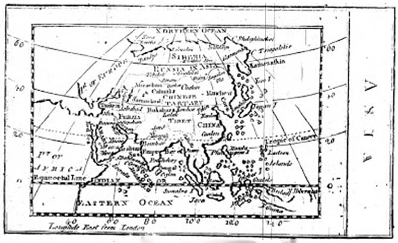
After
patiently downloading the 26 megabyte PDF file containing the scanned
book (click here and
then click on the "PDF" button), I was expecting a lengthy
discussion of Arabia to be among its 337 pages. Instead, there is one
short page of text and one map of Asia, neither of which I found
helpful.
The
text and map are below, with a zoomed-in section showing Arabia.
Click to enlarge.
Click Image to Magnify
Click Image to Magnify
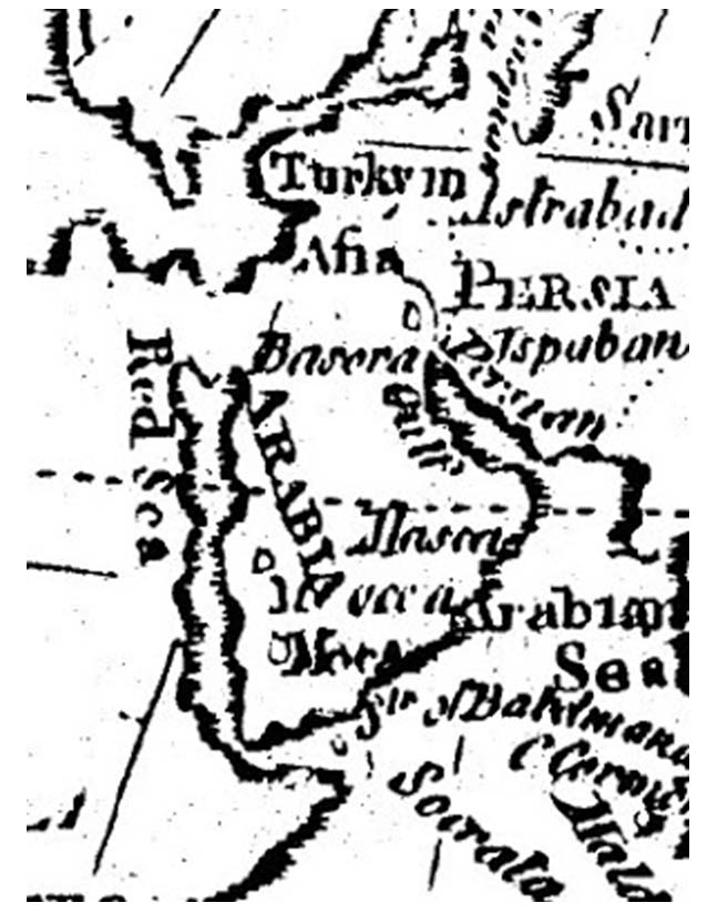
Zoomed section of map.
Click Image to Magnify
While
the colored map that was printed in 1828 shows "Felix Arabia"
along the southern coast, we do not have that feature in the
black-and-white map in Morse's earlier book. But we do have a mention
of "Happy Arabia" (Arabia Felix). Was this enough to guide
Joseph Smith?
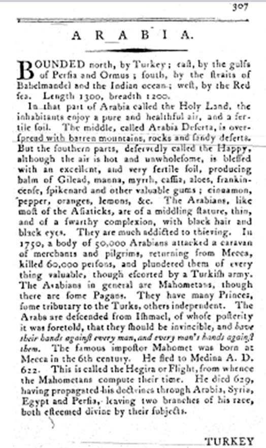
The
middle, called Arabia Deserta, is overspread with barren mountain,
rocks and sandy deserts. But the southern parts, deservedly called
the Happy, although the air is hot and unwholesome, is blessed with
an excellent, and very fertile soil, producing balm of Gilead, manna,
myrrh, cassia, aloes, frankincese, spikenard, and other valuable
gums; cinnamon, pepper, oranges, lemons, etc.
Hmm,
I'm struggling with this. There doesn't seem to be much guidance
given as to how one goes from Jerusalem to Bountiful, or where
Bountiful is.
Instead
of Bountiful on the eastern coast, where excellent candidates exist,
the best we can do based on Morse is head for the more southern parts
— but how to get across all the barren rocks and sandy deserts
of the middle section?
And
once we get to the south, mind you, we might expect a fabricated Book
of Mormon to have Laman and Lemuel whining about the "hot and
unwholesome" air, while Nephi says something like, "Behold,
we did rejoice in the spikenard and other exceedingly precious gums,"
accompanied by an occasional miracle of healing with the balm of
Gilead, perhaps after Lemuel pummels him with lemons.
But
such inspiring drama based on Jedidiah Morse seems conspicuously
absent from the Book of Mormon, while Nephi's tale seems utterly
unrelated to anything Morse describes.
Joseph
Smith, ever the reckless plagiarizer, didn't even have the courtesy
to borrow a few of the place names that Jedidiah offered on his maps
(why not mention Sana, Medina, Mecca, or especially Mocha?),
stubbornly sticking with names like Shazer, Nahom, and Bountiful.
And
foolishly, Joseph insisted on having Lehi's crew traipse straight
through the middle section of Arabia (following a south-southeast
direction that would later be understood to be completely plausible),
and then, having buried Ishmael at Nahom (the name corresponding to
an ancient burial site and an ancient tribe in that region, verified
by the modern discovery of engraved altars from that era), Joseph
completely disses Morse by failing to continue south into Happy
Arabia, but instead has Nephi turn nearly due east — in a
strangely plausible manner that bypasses the deadly Empty Quarter,
heading for the eastern coast, where they encounter Bountiful, a
place so pleasant that Laman and Lemuel don't want to leave, a place
that now, long after Joseph's day, appears remarkably plausible with
a recently discovered candidate at Khor Kharfot.
Perhaps
the hot and unwholesome air of Happy Felix scared Joseph off. But I
still insist it was a missed opportunity for our careless fabricator,
even though you have to admit he got awfully lucky with his wildly
uneducated guesses about the Arabian Peninsula.
Frankly, Joseph
Smith's vast frontier library might
as well have burned its copies of Jedidiah Morse's works, for all the
good they did him. But that's just my opinion, and I am still
struggling to find an answer for our friend who is convinced that
Morse gave Joseph Smith all he needed for the lame "revealed"
text in First Nephi dealing with the journey through the Arabian
Peninsula.
Any
hints? Am I missing something? Did Morse, like Solomon Spaulding,
have a secret second manuscript with the real stuff that Joseph
stole? Perhaps Arabian
Geography for Dummies and Charlatans: The Hidden Manuscript?
Or perhaps a magic map of mystery pinned up on his wall? I welcome
your feedback.
Jeff Lindsay has been defending the Church on the Internet since 1994, when he launched his
LDSFAQ website under JeffLindsay.com. He has also long been blogging about LDS matters on
the blog Mormanity (mormanity.blogspot.com). Jeff is a longtime resident of Appleton,
Wisconsin, who recently moved to Shanghai, China, with his wife, Kendra.
He works for an Asian corporation as head of intellectual property. Jeff and Kendra are the parents of 4 boys, 3 married and the the youngest on a mission.
He is a former innovation and IP consultant, a former professor, and former Corporate Patent
Strategist and Senior Research Fellow for a multinational corporation.
Jeff Lindsay, Cheryl Perkins and Mukund Karanjikar are authors of the book Conquering
Innovation Fatigue (John Wiley & Sons, 2009).
Jeff has a Ph.D. in Chemical Engineering from Brigham Young University and is a registered US
patent agent. He has more than 100 granted US patents and is author of numerous publications.
Jeff's hobbies include photography, amateur magic, writing, and Mandarin Chinese.